Water and Sewer Service to Megasite
Because we now know that the Mayor of the the City of Greensboro has promised to provide water and sewer service to the megasite, it seems important to see exactly where water and sewer service stops and where city watershed boundary lines lie.
Here is a link to a map showing the city water and sewer service areas: http://www.greensboro-nc.gov/modules/showdocument.aspx?documentid=3612
Here is a link to the city's map showing the city water watershed areas.
http://www.greensboro-nc.gov/modules/showdocument.aspx?documentid=3611
Paste these links into your browser and the maps will pop right up.
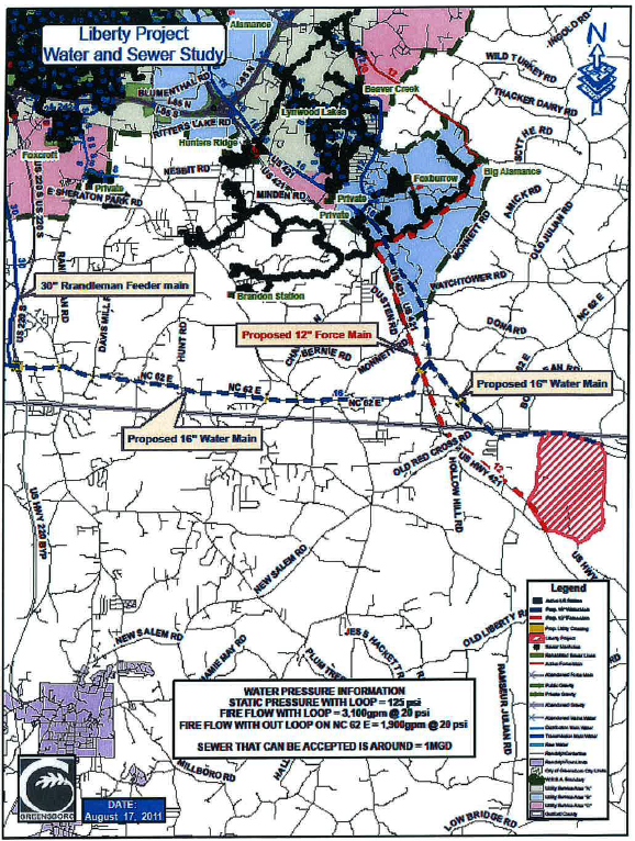
This is a City of Greensboro map showing the location of the proposed water and sewer lines to serve the proposed Randolph County megasite. The water line (the dotted blue line) would run along NC 62 through Climax to Hemphill Road, and then up Hemphill Road. It would pass underneath US 421 and continue along Bora Road to connect with a new line running down Liberty Road and continuing on into Randolph County. The new sewer line (dotted red line) would run down from the existing pumping station near Alamance Church Road. The map is not sufficiently detailed to know the exact location of the sewerage, but it appears to cross properties on Blakeshire Road, Woody Mill Road, Foxburrow Road, Southstone Road and Methodist Road, where it would then travel south passing underneath NC 62 and the Randolph County line and three miles farther to the new industrial site.